Selasa, 28 Juli 2009

SARI TEMPLE

This Buddhist temple is located about 600 meters north east of Kalasan temple on the north side of the main road between Yogyakarta and Solo. It is a slender and beautiful temple consisting of two floors. The upper floor was formerly used to keep religious relics. This temple was formerly a Buddhist sanctuary
or Vihara where the Buddhist priest used to live, meditate, and teach their followers. The wall of the temple is also protected with Vajralepa.

KALASAN TEMPLE

KALASAN TEMPLE

Kalasan Temple is built in Kalasan village about 2 km west of Prambanan, 15 km from Yogyakarta. _It is dedicated to a Buddhist Goddess, TARA. It is 6 meters tall and has 52 stupas. This unique Buddhist temple is located east of Yogyakarta, on the south side of the main road between Yogyakarta and Solo. It was built in honor of the marriage between king Pancapana of Sanjaya Dynasty and a Princess of Syailendra Dynasty, named Dyah Pramudya Wardhani. It is beautifully ornamented with finely carved relief and coated with "vajralepa", a yellowish material made from the sap of a certain tree. The vajralepa functioned as an adhesive and as protection against moss and mildew, while at the same time it refined the carvings. This temple is 24 m high and its base built in the form of a Greek cross.

tugu jogjakarta

Tugu Jogja is the most popular landmark of Yogyakarta. This monument is located right in the center of the crossroad between the Mangkubumi, Soedirman, A.M. Sangaji and Diponegoro roads. The Tugu Jogja that is almost 3 centuries old has a very deep meaning and it keeps some history records of Yogyakarta.

Tugu Jogja was built around one year after the construction of Yogyakarta Kingdom. At the early time of its construction, it clearly described the philosophy of the unity of God's creatures that means the spirit of togetherness of lay people and authorities to fight colonials. In Javanese term, the spirit of togetherness is called golong gilig that is clearly described in the construction of the monument: the pole is of gilig (cylinder) form and the top part is golong (rounded). This monument was known as Tugu Golong-Gilig.

In details, the monument was originally constructed in the form of a cylindrical pole with conical form upwards. The base is an encircling fence while the top is rounded. The preliminary height of the monument was 25 meters.

Everything changed when on Monday, 10 June 1867, a big earthquake in Yogyakarta ruined the monument. The collapse of the monument was the transition time when the unity was not really reflected on the monument.

The situation changed totally when in 1889 the Dutch government renovated the monument. The monument was constructed as a square with each side being decorated with a kind of inscription containing the names of people who were involved in the renovation. The top portion is no longer rounded but a pointed cone. The height of the monument is also lower, namely 15 meters. Since then, this monument was also called as De Witt Paal or Tugu Pal Putih (white pole monument).

The renovation of the monument was actually the tactic used by the Dutch colonial to erase the philosophy of togetherness between lay people and the king. Learning from the result of the struggle afterwards, however, the effort did not seem to be successful.

If we want to look at the monument satisfactorily while remembering its philosophical meaning, there are benches facing the monument on the corner of Mangkubumi Street. At 05:00 a.m. - 06:00 a.m. is the right time since the air is still fresh and not much passerby yet. Occasionally, the newspaper boy will greet us politely while riding his bicycle to go to the distribution office of the biggest local newspaper, the Kedaulatan Rakyat.

In the evening, we find the seller of gudeg (traditional menu cooked from young jackfruit) at the corner of Diponegoro Road. The gudeg sold here is delicious at reasonable price. You may have it in crossed-legs seating arrangement while looking at the view of the Tugu Jogja that is bathed with lights.

Being so identical of the Tugu Jogja to Yogyakarta makes many university students from outside of Yogyakarta to express their happiness after the graduation day by hugging and kissing the Tugu Jogja. That may also express their love to Yogyakarta that they will about to leave soon and at the same time say their promise to return to this city.

MOUNT MERAPI

Mount Merapi
Merapi, July 2005
Elevation 2,968 metres (9,738 ft)[1]
Location Border of Central Java / Yogyakarta (Indonesia)
Coordinates 7°32′26.99″S 110°26′41.34″E / 7.5408306°S 110.4448167°E / -7.5408306; 110.4448167Coordinates: 7°32′26.99″S 110°26′41.34″E / 7.5408306°S 110.4448167°E / -7.5408306; 110.4448167
Type Stratovolcano
Age of rock 400,000 years
Last eruption 2008[1]
Translation Mountain of Fire (Indonesian)

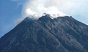
Mount Merapi, Gunung Merapi in Indonesian language, is a conical volcano located on the border between Central Java and Yogyakarta, Indonesia. It is the most active volcano in Indonesia and has erupted regularly since 1548. Its name means Mountain of Fire. It is very close to the city of Yogyakarta, and thousands of people live on the flanks of the volcano, with villages as high as 1700 m above sea level.

Although smoke can be seen emerging from the mountain top at least 300 days a year, several eruptions have caused fatalities. Hot gas from a large explosion killed 43 people in 1994, mostly in the town of Muntilan, west of the volcano. Another large eruption occurred in 2006, shortly before the Yogyakarta earthquake. In light of the hazards that Merapi poses to populated areas, it has been designated as one of the Decade Volcanoes.

Contents

[hide]

[edit] Geological history

Merapi before 2007 eruption.

Merapi is the youngest in a group of volcanoes in southern Java. It is situated at a subduction zone, where the Indo-Australian Plate is sliding beneath the Eurasian Plate. It is one of at least 129 active volcanoes in Indonesia, part of the Pacific Ring of Fire – a section of fault lines stretching from the Western Hemisphere through Japan and South East Asia.[2] Stratigraphic analysis reveals that eruptions in the Merapi area began about 400,000 years ago, and from then until about 10,000 years ago, eruptions were typically effusive, and the outflowing lava emitted was basaltic. Since then, eruptions have become more explosive, with viscous andesitic lavas often generating lava domes. Dome collapse has often generated pyroclastic flows, and larger explosions, which have resulted in eruption columns, have also generated pyroclastic flows through column collapse.

Typically, small eruptions occur every two to three years, and larger ones every 10-15 years or so. Notable eruptions, often causing many deaths, have occurred in 1006, 1786, 1822, 1872 (the most violent eruption in recent history), and 1930—when thirteen villages were destroyed and 1400 people killed by pyroclastic flows.

A very large eruption in 1006 is claimed to have covered all of central Java with ash. The volcanic devastation is claimed to have led to the collapse of the Hindu Kingdom of Mataram, however there is insufficient evidence from that era for this to be substantiated.

Merapi continues hold particular significance for the Javanese: it is one of four places where officials from the royal palaces of Yogyakarta and Solo make annual offerings to placate the ancient Javanese spirits.[3]

[edit] 2006 eruption

Pyroclastic flows (2006)

In April 2006, increased seismicity at more regular intervals and a detected bulge in the volcano's cone indicated that fresh eruptions were imminent. Authorities put the volcano's neighboring villages on high alert and local residents prepared for a likely evacuation. On April 19 smoke from the crater reached a height of 400 meters, compared to 75 metres the previous day. On April 23, after nine surface tremors and some 156 multifaced quakes signalled movements of magma, some 600 elderly and infant residents of the slopes were evacuated.[4]

By early May, active lava flows had begun. On May 11, with lava flow beginning to be constant, some 17,000 people were ordered to be evacuated from the area[5] and on May 13, Indonesian authorities raised the alert status to the highest level, ordering the immediate evacuation of all residents on the mountain.[6] Many villagers defied the dangers posed by the volcano and returned to their villages, fearing that their livestock and crops would be vulnerable to theft.[7] Activity calmed by the middle of May.[8]

On May 27, a 6.2 magnitude earthquake struck roughly 30 miles southwest of Merapi, killing at least 5,000 and leaving at least 200,000 people homeless in the Yogyakarta region, heightening fears that Merapi will "blow".[9] The quake did not appear to be a long-period oscillation, a seismic disturbance class that is increasingly associated with major volcanic eruptions. A further 11,000 villagers were evacuated on June 6 as lava and superheated clouds of gas poured repeatedly down its upper slopes.[10] The pyroclastic flows are known locally as "wedhus gembel" (Javanese for "shaggy goat").

[edit] Monitoring

Merapi Volcano January 27, 2007.
Merapi next to Merbabu January 9, 2008

Mount Merapi is the site of a very active volcano monitoring program. Seismic monitoring began in 1924, with some of the volcano monitoring stations lasting until the present. The Babadan (north west location), Selo (in the saddle between Merbabu and Merapi), and Plawangan monitoring stations have been updated with equipment over the decades since establishment. During the 1950s and early 1960s some of the stations were starved of equipment and funds, but after the 1970s considerable improvement occurred with the supply of new equipment. Some of the pre-1930 observation posts were destroyed by the 1930 eruption, and newer posts were re-located. Similarly after the 1994 eruption, the Plawangan post and equipment were moved into Kaliurang as a response to the threat of danger to the Volcanological personnel at the higher point.

The eruption of 1930 was found to have been preceded by a large earthquake swarm. The network of 8 seismographs currently around the volcano allow volcanologists to accurately pinpoint the hypocentres of tremors and quakes.

A zone in which no quakes originate is found about 1.5 km below the summit, and is thought to be the location of the magma reservoir which feeds the eruptions.

Other measurements taken on the volcano include magnetic measurements and tilt measurements. Small changes in the local magnetic field have been found to coincide with eruptions, and tilt measurements reveal the inflation of the volcano caused when the magma chambers beneath it is filling up.

Lahars (a type of mudflow of pyroclastic material and water) are an important hazard on the mountain, and are caused by rain remobilizing pyroclastic flow deposits. Lahars can be detected seismically, as they cause a high-frequency seismic signal. Observations have found that about 50 mm of rain per hour is the threshold above which lahars are often generated.

Senin, 30 Juli 2007

Tradition and Multiethnicity in indonesia

In the early 1990s, Indonesia's society was divided into numerous ethnic groups and minorities. The largest group were the Javanese at 45 percent of the total population. Sundanese made up 14 percent, followed by Madurese, 7.5 percent, and coastal Malays, 7.5 percent. As a sign of its diverse population, fully 26 percent of the population in 1992 consisted of numerous small ethnic groups or minorities. The extent of this diversity is unknown, however, since Indonesian censuses do not collect data on ethnicity.

As this increasingly mobile, multiethnic nation moved into its fifth decade of independence, Indonesians were made aware--through education, television, cinema, print media, and national parks--of the diversity of their own society. When Indonesians talk about their cultural differences with one another, one of the first words they use is adat (custom or tradition). This term adat is roughly translated as "custom" or "tradition," but its meaning has undergone a number of transformations in Indonesia. In some circumstances, for instance, adat has a kind of legal status--certain adat laws (hukum adat) are recognized by the government as legitimate. These ancestral customs may pertain to a wide range of activities: agricultural production, religious practices, marriage arrangements, legal practices, political succession, or artistic expressions.

Despite the fact that the vast majority of Indonesians are Muslim, they maintain very different social identifications. For example, when Javanese try to explain the behavior of a Sundanese or a Balinese counterpart, they might say "because it is his adat." Differences in the ways ethnic groups practice Islam are often ascribed to adat. Each group may have slightly different patterns of observing religious holidays, attending the mosque, expressing respect, or burying the dead.

Although adat in the sense of "custom" is often viewed as one of the deepest--even sacred--sources of consensus within an ethnic group, the word itself is actually of foreign derivation-- originally from the Arabic. Through centuries of contact with outsiders, Indonesians have a long history of contrasting themselves and their traditions with those of others, and their notions of who they are as a people have been shaped in integral ways by these encounters. On the more isolated islands in eastern Indonesia, for instance, one finds ethnic groups that have no word for adat because they have had very little contact with outsiders.

In the 1970s and 1980s, the notion of adat came to take on a national significance in touristic settings such as Balinese artistic performances and in museum displays. Taman Mini, a kind of ethnographic theme park located on the outskirts of Jakarta, seeks to display and interpret the cultural variation of Indonesia. From its groundbreaking in 1971 and continuing after its completion in 1975, the park was surrounded in controversy, not least because its construction displaced hundreds of villagers whose land was seized in order to finish the job. Nonetheless, a 100-hectare park was landscaped to look like the archipelago of Indonesia in miniature when viewed from an overhead tramway. There was a house for each province to represent the vernacular architecture of the region. Distinctive local hand weapons, textiles, and books explaining the customs of the region were sold. The powerful message of the park was that adat is contained in objective, material culture, that it is aesthetically pleasing and indeed marketable, but that it is more or less distinct from everyday social life. Furthermore, the exhibits conveyed the impression that ethnicity is a relatively simple aesthetic matter of regional and spatial variations rather than a matter of deep emotional or political attachments. However, the park provided visitors with a vivid and attractive (if not always convincing) model for how the Indonesian national motto-- Unity in Diversity (Bhinneka Tunggal Ika, a Javanese motto dating to the fifteenth century Kingdom of Majapahit)--might be understood.

When Indonesians talk about their society in inclusive terms, they are more likely to use a word like budaya (culture) than adat. One speaks of kebudayaan Indonesia, the "culture of Indonesia," as something grand, and refers to traditions of refinement and high civilization. The Hinduized dances, music, and literature of Java and Bali and the great monuments associated with their religion are often described as examples of "culture" or "civilization" but not "custom." However, as the following descriptions show, the wide variety of sources of local identification underscore the diversity rather than the unity of the Indonesian population.

Javanese Sundanese Balinese Peoples of Sumatra Ethnic Minorities